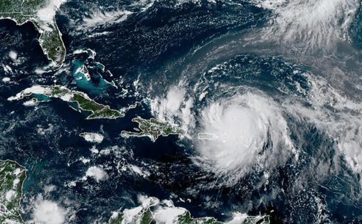
Hurricane Erin path shifts, prompts new warnings as NHC tracks 2 other Atlantic systems
Published in Weather News
Hurricane Erin on Sunday dropped in intensity overnight, but was expected to regain strength while its path shifted prompting new warnings and watches to be issued by the Bahamas while the National Hurricane Center kept track of two other Atlantic systems.
As of the NHC’s 11 a.m. advisory, the center of Erin was located about 200 miles north-northwest of San Juan, Puerto Rico and 240 miles east of Grand Turk Island moving west-northwest at 13 mph with maximum sustained winds of 125 mph, which makes it a Category 3 hurricane.
“This general motion is expected today, followed by a gradual turn to the north on Monday and Tuesday,” said NHC senior hurricane specialist Richard Pasch. “On the forecast track, the core of Erin is expected to pass to the east of the Turks and Caicos Islands and the southeastern Bahamas tonight and Monday.”
The path shifted more to the south and west than previous projections.
The government of the Bahamas issued a tropical storm warning for the Turks and Caicos and a tropical storm watch for the southeast Bahamas. The NHC noted interests in the Virgin Islands, Puerto Rico and central Bahamas should monitor the progress of Erin, while its long-term path could mean outer band winds might affect the Carolina and mid-Atlantic coast of the U.S.
The storm became the season’s first hurricane at 11 a.m. Friday, with 75 mph winds, but grew to a “catastrophic” Category 5 hurricane in just one day, undergoing rapid intensification that had sustained winds of up to 160 mph. It began to lose intensity late Saturday after pushing just north of the northern Leeward Islands.
“This slight decrease in intensity is probably due to an eyewall replacement in the inner core, as reported by the Hurricane Hunters, and is likely a temporary short-term fluctuation,” Pasch said. “The system remains a well-organized and dangerous major hurricane with a impressively symmetric cloud pattern.”
It’s forecast to remain a powerful hurricane for the next several days, and its wind field is beginning to grow.
“Erin is growing in size, and that trend is expected to continue over the next few days,” Pasch said. “The expanding wind field will result in rough ocean conditions over much of the western Atlantic.”
Hurricane-force winds extend out 25 miles while tropical-storm-force winds extend out 205 miles.
Outer bands continue to lash the Virgin Islands, Puerto Rico and Dominican Republic on Sunday, with 4-6 inches of rain in many places, but some areas that could get up to 8 inches. The could lead to flash and urban flooding, along with landslides or mudslides.
The system passed by the Cape Verde Islands earlier in the week, causing flash floods blamed for at least nine deaths. It has been moving quickly across the Atlantic.
The swells from the storm with dangerous surf and rip currents continue to hit the northeastern Caribbean islands and by early next week are forecast to spread to the Bahamas, Florida and rest of the U.S. East Coast as the storm intensifies and moves up into the Atlantic.
“The forecast cone takes the storm well east of Florida, but coastal impacts are forecast next week,” the National Weather Service in Melbourne stated. “Surf, rip current and boating impacts reach our coast starting Monday and will peak Tuesday-Wednesday.”
The NHC was also keeping track of two other systems in the Atlantic with a chance to develop into the season’s next tropical depression or storm. The next name on the list after Erin is Fernand.
As of the NHC’s 8 a.m. tropical outlook, the most concerning system for Florida was an area of low pressure that could form by midweek from a tropical wave near the Cape Verde Islands, producing disorganized showers and thunderstorms and trailing the path of Hurricane Erin in the central tropical Atlantic.
“Some gradual development of this system is possible during the middle to latter portion of the week while the system moves westward to west-northwestward at 15 to 20 mph across the eastern and central tropical Atlantic,” forecasters said.
The NHC gave it a 20% chance to develop in the next seven days.
The NHC also continued to track an area of low pressure a couple hundred miles off the coast of North Carolina that had disorganized shower activity to the east of the center.
“Development, if any, of this system should be slow to occur during the next day or so while it moves little over the warm waters of the Gulf Stream,” forecasters said. “The opportunity for development should end on Monday, when environmental conditions are expected to become unfavorable.”
The NHC gave it a 10% chance to develop in the next two days.
The National Oceanic and Atmospheric Administration recently updated its season forecast, now calling for 13-18 named storms for the year, of which five to nine would grow into hurricanes. Two to five of those would develop into major hurricanes of Category 3 strength or higher.
The height of hurricane season runs from mid-August into October while the entire six-month season runs June 1 to Nov. 30.
_____
©2025 Orlando Sentinel. Visit orlandosentinel.com. Distributed by Tribune Content Agency, LLC.


Comments